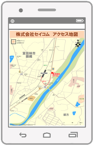
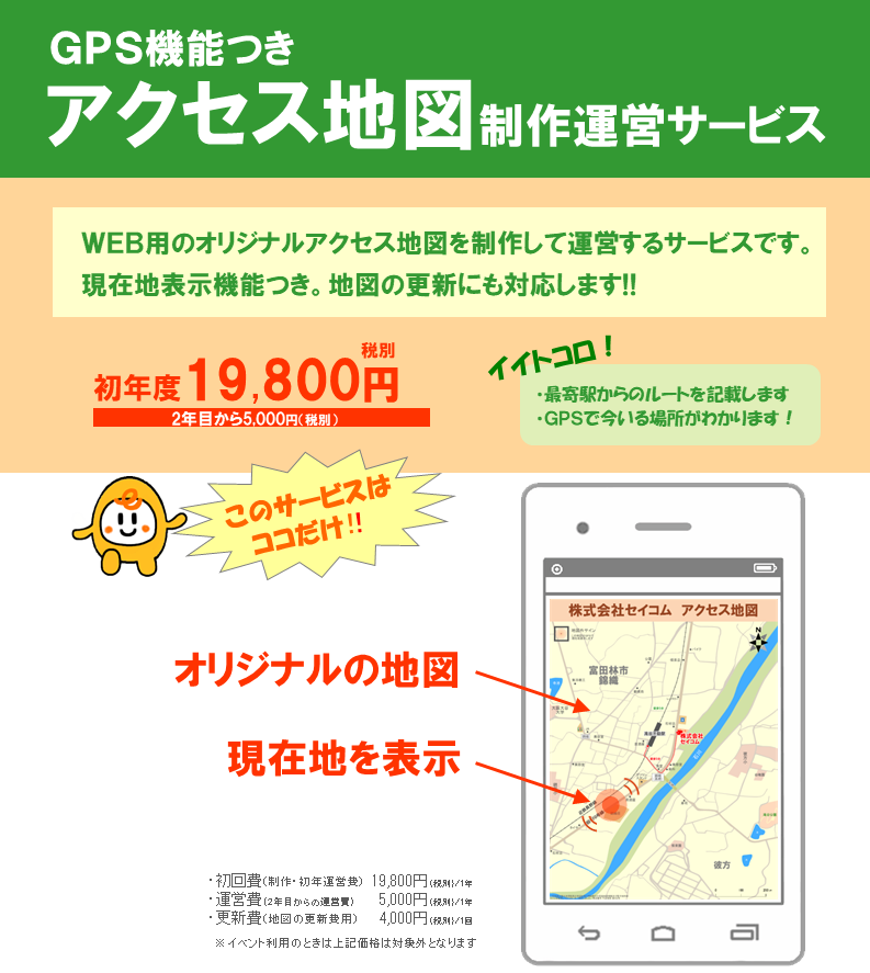
Home
myO-map. Drawing Tool for Orienteering maps (o-sport)
Release 1.3.0 PDF Print E-mail
Written by Administrator   
Wednesday, 16 March 2011 10:30
  • Program is adapted and tested on device with 800x480 screen resolution (6" and 7")
  • User can set real display DPI in options window
  • User can change column count on symbol panel (from 2 to 6. 5 is optimal value for 800x480)
  • Added menu for displaying relief, hydro, ... or all symbols on panel (like OCAD)
  • Changing in symbol colors: relief - chocolate, dist. veget. boundary - dark green
  • On selecting object it's symbol name is displayed at bottom label

Download http://www.o-map.net/downloads/myomap-1.3.0.zip

http://www.o-map.net/downloads/myomap-1.3.0_800x480.zip

Last Updated on Tuesday, 04 October 2011 09:53
 
How to create a new map PDF Print E-mail
Written by Administrator   
Wednesday, 06 October 2010 11:32

Description of creating map file with assistance of sattelite photo.

  1. Try to get an image from sattelite (One tool is http://sasgis.ru/sasplaneta/). More...
  2. Create GPX-file with 2 points and enter coordinates of upper left and bottom right corners of image.
  3. Create new map in OCAD (1:10000), making sattelite view as background.
  4. Load the GPX-file (more) and adjust the background by it.
  5. Draw countour of visible objecst from sattelite: buildings, roads, paths...
  6. After this steps you can begin draw on GPS device.
Last Updated on Monday, 11 October 2010 13:39
 
myO-map screenshots PDF Print E-mail
Written by Administrator   
Friday, 11 December 2009 11:01

Main Screen

Last Updated on Friday, 11 December 2009 07:01
Read more...
 
myO-map features PDF Print E-mail
Written by Administrator   
Friday, 11 December 2009 10:00

myO-map is FREE application for drawing/editing O-maps on Windows Mobile and Windows CE devices (PDA, Navigators) with (or without) GPS.

Other features:

  • Drawing modes: lines, freehand, bezier curves, rectangles, points, text
  • Moving objects and object points
  • Almost full set of OCAD symbols
  • Easy files transfer: just copy it from mobile device to desktop computer and back
  • Map scales from 1:100 to 1:100000
  • On GPS-based devices you can use it for more precision drawing
  • Exporting GPS track (by gpx-file) from myO-map to OCAD
Last Updated on Monday, 14 December 2009 11:23
Read more...
 
Copyright © 2012 myO-map. Mobile O-map Drawing Tool for OCAD. All Rights Reserved.
Joomla! is Free Software released under the GNU/GPL License.
 

Polls

What OCAD version you are using?
 

Deprecated: Function ereg_replace() is deprecated in /home/roman/o-map.net/docs/plugins/system/jfdatabase/jfdatabase_inherit.php on line 566